The Calumet region, as defined in this tool, includes the far south side of Chicago and Cook County’s south suburbs. The region is large, but shares a number of characteristics: diverse in population - known for its predominantly Black communities, historically industrial economy, and a wealth of valuable natural resources for its residents.
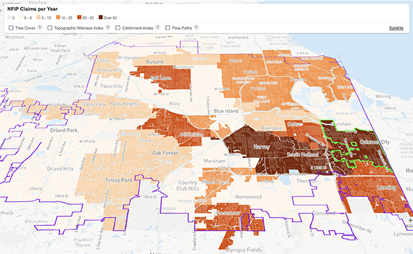
The region, previously known as the Millenium Reserve, experiences some of the highest numbers of flooding events and damage in Cook County. The area’s urban and riverine flooding impact the quality of life, environment, and infrastructure systems like streets, businesses, and homes. CNT’s past work on flooding data has shown damages to be concentrated in low-income communities and communities of color. The Calumet region illustrates the overlap between race, income, and flooding: it is one of the region’s lowest-income areas, many of its residents are people of color, and it experiences flooding frequently.
The Urban Flooding Baseline Tool seeks to inform community residents, and municipal and regional leaders that flooding is experienced across communities, not just within individual homes. The tool provides content knowledge to assist with community advocacy, municipal action, and regional stormwater planning efforts. Flooding is a reality, but communities can take steps to reduce the impact.
CNT developed the Urban Flooding Baseline to serve as a mapping tool and data source to visualize “where it is flooding,” “why it is flooding,” and “what are the impacts” for community residents and leaders. The data is focused on the municipal level, not on individual households or parcels. CNT hopes that it can be used as an educational tool for individuals new to stormwater management, spark discussions in communities, and act as a starting point for community stakeholders to advocate for better stormwater management practices within their municipalities.
The CNT Flood Photo App was a critical component of the Urban Flooding Baseline Project. CNT explored how qualitative data can complement quantitative data in the stormwater management field. 3-1-1 phone systems, which originally inspired the app, are used by many municipalities to track resident complaints about various issues, including flooding. However, white, middle-class or wealthier communities who city governments have developed trust with use 3-1-1 systems more often than Black or brown communities that may not have a trusting relationship of the government due to historic policies and practices. Additionally, smaller municipalities or those with lower financial capacity do not have a systematic way of logging resident complaints, which is the case for several municipalities in the Calumet region.
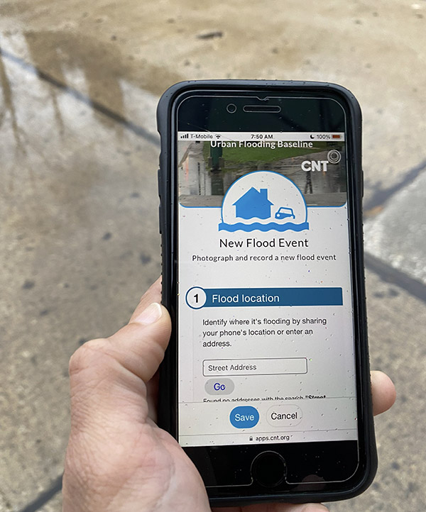
CNT innovated a system for compensated data collection of flood-prone areas. CNT hired residents as data collectors to center the voices of the people directly impacted, since they understand the experience of flooding best and have intimate, local contextual knowledge. These residents were trained and paid for their time spent collecting data. Data collectors used the app to capture photos of standing water after storm events. The app included multiple functions: a photo upload section, location and date information of the photo, fill-in text boxes for data collectors to respond to, and a map visualizing the locations tracked over time.
Please reach us at ufbaseline@cnt.org to learn more about this app.
We would like to especially thank our data collectors for their time and effort to collect the stormwater photos: Brittini Bridges, Gerard Evans, Mary Evans, Jacquelene Ford, Mercedes Gross, Esther Heyboer, Rachel Heyboer, Dorothy Mars, Dennis Murray, Latonya Nalls, Victoria Nicholson, Jarice Shaw, Joyce Shaw, Marsha Shields, Lorée Washington, Tempestt Wesley, Nylah Windrom, and Stephanie Windrom.
Special thanks to Advisory Group members Rachel Heyboer, Joyce Shaw, and Lorée Washington for the resident perspective throughout the development of this project and to Karen Kreis and Helen Kavich for their additional input.
Additional thanks to South Suburban Mayors and Managers Association for their partnership throughout the project and the Calumet Stormwater Collaborative members for their support.
CNT would also like to thank the Crown Family Philanthropies for their funding support on this project.
The quantitative methods document provides a detailed listing of the indicators showcased in the Maps and Analysis section of the website. The documentation includes information on the source, geographic scale, and vintage of the data.
Download Quantitative Methods »
Community engagement is a vital part of development projects and promoting resilient communities. It is important to understand stormwater impacts not only based on how it affects infrastructure but especially the effects on residents. Between March 2021-May 2022, CNT hired 15 residents (data collectors) from within the Calumet Region to collect photos of stormwater concerns after storm events in the communities of Dixmoor, Dolton, Harvey, Markham, Phoenix, Posen, and Riverdale. These municipalities were chosen because MWRD prioritized these in a Stormwater Master Plan process, which was eventually published in 2022. The goal was to build out the process to compensate residents for data collection so that municipalities or other groups could hire residents to collect qualitative data for stormwater management planning processes.
The Urban Flooding Baseline Tool seeks to inform community residents, and municipal and regional leaders that flooding is experienced across communities, not just within individual homes. The tool provides content knowledge to assist with community advocacy, municipal action, and regional stormwater planning efforts. Flooding is a reality, but communities can take steps to reduce the impact.
![]()
Analysis and web tool design by
Center for Neighborhood Technology
Released January, 2023
Explore the ‘Where’ and ‘Why’ of Urban Flooding, and Who Is Most Impacted